Exam questions: Chart work
8 questions with the answer, the explanation and the official rule behind it. Part of the PER syllabus.
Chart work is an eliminating block: you must get at least 2 questions right in this block to pass, even if your overall score would be enough.
-
1
Scenario: you wish to sail in a straight line from Punta Levante light (36°27′N 005°52′W) to Cabo Sirena light (36°03′N 005°33′W). Measure on the chart using the rose and the latitude scale.
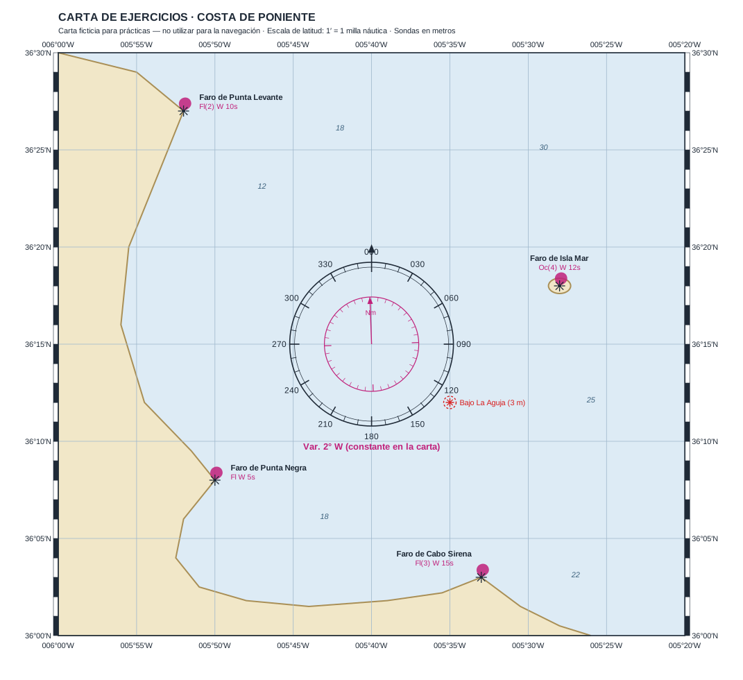
¿Qué rumbo verdadero (Rv) hay que seguir para ir del Faro de Punta Levante al Faro de Cabo Sirena?
- Rv = 147° Correct answer
- Rv = 135°
- Rv = 160°
- Rv = 327°
Why?
Drawing the track between the two lights and measuring with the rose, the true course is 147°. The boat heads SE (latitude decreasing, longitude moving east). 327° is the return (reciprocal) course, a classic mistake.
Source Carta de ejercicios ficticia «Costa de Poniente» — no válida para la navegación · Método: estima plana con la corrección del coseno de la latitud media (36°15′N) · Temario: RD 875/2014, anexo II, UT11 «Carta de navegación» (BOE-A-2014-10344)
-
2
Scenario: you wish to sail in a straight line from Punta Levante light (36°27′N 005°52′W) to Cabo Sirena light (36°03′N 005°33′W). Measure on the chart using the rose and the latitude scale.
¿Qué distancia hay entre el Faro de Punta Levante y el Faro de Cabo Sirena?
- 28,5 millas Correct answer
- 30,5 millas
- 24 millas
- 33 millas
Why?
Distance is measured on the latitude scale (1′ = 1 mile) and is about 28.5 miles. Note: longitude minutes do not equal 1 mile except at the equator; measuring them as miles (without the cosine-of-latitude correction) would give about 30.5 miles, the typical error.
Source Carta de ejercicios ficticia «Costa de Poniente» — no válida para la navegación · Método: estima plana con la corrección del coseno de la latitud media (36°15′N) · Temario: RD 875/2014, anexo II, UT11 «Carta de navegación» (BOE-A-2014-10344)
-
3
Scenario: while underway, you take two true bearings at the same time. Plot the line of position from each lighthouse and find the intersection to fix your position.
Observa simultáneamente una demora verdadera de 321° al Faro de Punta Levante y de 098° al Faro de Isla Mar. ¿Cuál es su situación?
- 36°20′N 005°45′W Correct answer
- 36°22′N 005°40′W
- 36°17′N 005°48′W
- 36°15′N 005°40′W
Why?
From each lighthouse you draw the line of position along its bearing; the intersection of the two gives the fix: 36°20′N 005°45′W. The two bearings should cross at a good angle (here ~137°) for the fix to be reliable.
Source Carta de ejercicios ficticia «Costa de Poniente» — no válida para la navegación · Método: intersección de las dos líneas de posición trazadas sobre la carta · Temario: RD 875/2014, anexo II, UT11 «Carta de navegación» (BOE-A-2014-10344)
-
4
Scenario: while underway, you take two true bearings at the same time. Plot the line of position from each lighthouse and find the intersection to fix your position.
Observa simultáneamente una demora verdadera de 244° al Faro de Punta Negra y de 126° al Faro de Cabo Sirena. ¿Cuál es su situación?
- 36°10′N 005°45′W Correct answer
- 36°08′N 005°50′W
- 36°12′N 005°41′W
- 36°06′N 005°47′W
Why?
Plotting the two lines of position from Punta Negra and Cabo Sirena along their bearings, they cross at 36°10′N 005°45′W. The option 36°08′N 005°50′W is Punta Negra lighthouse itself: a trap, not the boat's position.
Source Carta de ejercicios ficticia «Costa de Poniente» — no válida para la navegación · Método: intersección de las dos líneas de posición trazadas sobre la carta · Temario: RD 875/2014, anexo II, UT11 «Carta de navegación» (BOE-A-2014-10344)
-
5
Scenario: you depart from 36°25′N 005°45′W steering a true course of 180° at 6 knots, with no current or leeway.
Gobernando a 6 nudos, ¿qué distancia habrá recorrido al cabo de 2 horas?
- 12 millas Correct answer
- 6 millas
- 3 millas
- 8 millas
Why?
Distance = speed × time = 6 knots × 2 hours = 12 miles. A knot is one nautical mile per hour, so the calculation is direct.
Source Carta de ejercicios ficticia «Costa de Poniente» — no válida para la navegación · Método: distancia = velocidad × tiempo · Temario: RD 875/2014, anexo II, UT11 «Carta de navegación» (BOE-A-2014-10344)
-
6
Scenario: you depart from 36°25′N 005°45′W steering a true course of 180° at 6 knots, with no current or leeway.
Tras recorrer 12 millas al rumbo verdadero de 180° desde 36°25′N 005°45′W, ¿cuál es su situación de estima?
- 36°13′N 005°45′W Correct answer
- 36°37′N 005°45′W
- 36°13′N 005°33′W
- 36°25′N 005°33′W
Why?
A course of 180° is due south: longitude does not change and latitude decreases by 12′ (12 miles = 12′ of latitude). From 36°25′N you go down to 36°13′N, keeping 005°45′W. Adding instead of subtracting would give 36°37′N, a common error.
Source Carta de ejercicios ficticia «Costa de Poniente» — no válida para la navegación · Método: rumbo 180°: la longitud no varía y la latitud disminuye en tantos minutos como millas · Temario: RD 875/2014, anexo II, UT11 «Carta de navegación» (BOE-A-2014-10344)
-
7
Scenario: use the variation shown on the chart's rose (Var. 2° W) to convert between true and compass courses/bearings. Take deviation as nil (Δ = 0°).
Desea hacer buena un rumbo verdadero (Rv) de 200°. Con Var. 2° W y desvío nulo, ¿qué rumbo de aguja (Ra) debe gobernar?
- 202° Correct answer
- 198°
- 200°
- 204°
Why?
The total correction is Ct = variation + deviation = −2° + 0° = −2°, because westerly variation is taken as negative. The relation between courses is Tc = Cc + Ct, so Cc = Tc − Ct = 200° − (−2°) = 202°. Put without the formula: with westerly variation the number on the compass card is greater than the true course, which is why you must steer 202° to make good a true course of 200°. The classic mnemonic sums it up: 'error west, compass best' — with westerly error the compass reads high.
Source Carta de ejercicios ficticia «Costa de Poniente» — no válida para la navegación · Método: Criterio de signos E (+) / W (−); Ct = dm + Δ; Ra = Rv − Ct, con Var. 2° W de la rosa de la carta · Temario: RD 875/2014, anexo II, UT11 «Carta de navegación» (BOE-A-2014-10344)
-
8
Scenario: use the variation shown on the chart's rose (Var. 2° W) to convert between true and compass courses/bearings. Take deviation as nil (Δ = 0°).
Toma una demora de aguja (Da) de 050° a un faro. Con Var. 2° W y desvío nulo, ¿cuál es la demora verdadera (Dv) que llevará a la carta?
- 048° Correct answer
- 052°
- 050°
- 046°
Why?
Total correction is Ct = −2° (west). To go from compass to true you add the correction: Tb = Cb + Ct = 050 + (−2) = 048°. This true bearing is the one plotted on the chart. Adding +2 instead of subtracting would give 052°, a sign error.
Source Carta de ejercicios ficticia «Costa de Poniente» — no válida para la navegación · Método: Criterio de signos E (+) / W (−); Dv = Da + Ct, con Var. 2° W de la rosa de la carta · Temario: RD 875/2014, anexo II, UT11 «Carta de navegación» (BOE-A-2014-10344)
That is all 8 questions on Chart work. Answering them with instant feedback sticks far better than reading them.